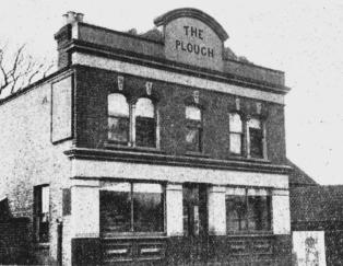
The Plough Public House

Southend Timeline Southend-on-Sea © 2009 - 2024. All Rights Reserved
The
first
Plough
was
built
in
an
orchard
belonging
to
Barlands
Farm.
The
farm
buildings
were
on
the
north
side
of
the
London-to
Southend
Road.
The
farm
itself
dated
back
to
at
least
the
15th
century.
There
is
a
record
that
-
"In
1469
John
Quyk,
of
Berlonds
(Barlands),
Prittlewell,
bequeathed
forty
shillings
towards
making
the
pinnacles
of
the
new
tower
[of
St
Mary's
Church]"
The
land
here
all
belonged
to
the
Scratton
family
(of
course)
and
would
have
been
leased
to
tenant
farmers.
It
is
Daniel
Robert
Scratton's
sale
of
his
land
when
he
retired
to
Devon
in
1869
that
allowed
tenants
to
buy
their
leases
outright
and
the
subsequent
owners
to
sell
on
their property. Thus the 1869 sale triggered the development of the area.
A
map
from
1873
shows
3
buildings,
presumably
dwellings,
on
the
south
side
of
the
road.
The
Plough
would
later
be
built
in
the
gap
between
the
middle
building
and
the
easternmost
one.
There
were
two
clear
phases
of
development
that
resulted
in
a
building
we
would
recognise.
I
can
find
no
records
of
the
subsequent
refurbishments
and minor alterations.
The first phase of development (1880-1882):
Essex
Records
hold
a
building
plan
for
the
Plough
Hotel
dated
1880.
This
is
followed
by
an
1882
plan
for
a
"House
[Plough
Hotel]"
and
plans
for
stables
at
the
"Plough
Inn"
also
dated
1882.
The
same
owners
(Seabrook
and
Son
/
C.
Seabrook)
appear
on
all
3
sets
of
plans.
The
builder
and
architect
are
not
named
in
the
records.
A
new
drainage
system was added to the property in 1897.
My
interpretation
of
the
plans
is
that
the
public
house
was
built
in
1880.
The
'house'
referred
to
in
the
1882
plan
was
most
probably
a
coach
house
that
was
built
with
the
stables
in
the
same
year.
The
buildings
are
all
shown
on
a
1897
map
where
the
pub
itself
is
marked
with
'B.H.'
(i.e.
beer
house).
There
is
a
coach
house
and
stables
to
west
of
the
pub
and
there
is
a
small
courtyard
between
the
pub and stables.
A
map
from
1897
shows
that
the
older
buildings
from
the
1873
map
that
are
unrelated
to
the
pub,
were
still
in
existence.
The
designation
'beer
house'
is
unusual.
The
maps
of
this
period
usually
label
pubs
as
'P.H.'
(i.e.
public
house)
and
the
Cricketers
further
along
the
road
is
labelled
that
way,
for
example.
This
suggests
that
it
may
have
also
been
a
brew
house,
having
a
brewing
operation
on
site.
This
was
not
unusual
when
pubs
were
owned
by
brewers
and
the
Minerva
brewed
beer
when
it
was
owned
by
Lukers
in
this
period.
Put
simply,
the
records
and
maps
confirm
that
the
Plough
was
built
as
the
Plough
Hotel
(a
public
house)
in
1880.
These
are
the
records of plans for the first phase of the building (from ERO):
Building plans submitted to Southend Local Board of Health: 1880-1889
Scope and Content:
Plough Hotel
London Road
Seabrook and Son
Dates of Creation:
1880
Building plans submitted to Southend Local Board of Health: 1880-1889
Scope and Content:
House [Plough Hotel]
London Road
C. Seabrook
Dates of Creation:
1882
Building plans submitted to Southend Local Board of Health: 1880-1889
Scope and Content:
Stable etc. at Plough Inn
London Road
C. Seabrook
Plans in very poor condition, were destroyed by Southend Corporation in 1981
Dates of Creation:
1882
Building plans submitted to Southend Borough Council for approval 1896-1897
Scope and Content:
New drainage at The Plough P.H. London Road Seabrook and Sons
Dates of Creation:
1897
The
plans
give
the
address
as
London
Road.
This
may
result
from
a
later
transcription
of
the
plans
and
as
we
know,
roads
sometimes
had
more
than
one
locally
used
name
in
this
period.
On
early
maps,
the
road
is
labelled
Leigh
Road.
Records
from
the
early
1900s
tell
us
that
the
junction
with
West
Road
was
known
locally
as
'Plough
Corner'.
The
importance
of
the
site
results
from
the
junction,
this
being
on
the
historic
route
from
London
to
the
religious
community
at
Southchurch
and
the
point
where
travellers
from
London
would
take
the
turning
into
West
Road
to
get
to
Prittlewell.
Despite
what
we
may
think
about
the
pub's
location
on
the
main
route,
there
is
no
evidence
that
it
was
a
coaching
stop/house.
In
fact
this
is
unlikely
as
it
was
built
24
years
after
the
arrival
of
the
railway
to
the
area.
The
stables
and
coach
house
would
more
likely
have
been
for
the
use
of
patrons
of
the
hotel
rather
than
as
a
coach
service
stop.
The
owner
of
the
hotel
C.
Seabrook
was
Charles
Seabrook,
the
CEO
of
Seabrook
&
Sons
(formerly
spelt
Seabrooke).
Seabrooks
were
a
long
established
brewery
based
in
Grays
with
historic
pubs
in
the
Grays/Thurrock
area.
It
seems
they
had
branched
out
along
the
London
Road
A13
route.
They
were
absorbed
by
Charringtons
in
1929.
The
owner
being
a
brewery,
they
probably
used
their
own
contracted
architect
and
builder
for
the
work
rather
than
local
firms.
Given
that
they
had
been
building
brick
outer
walls
around
their old, wooden framed pubs, they may even have had an in-house architect/builder.
The second phase of development (1904-1905):
Essex
Records
hold
a
further
set
of
building
plans
for
the
Plough
Inn
(1903),
the
'new
Plough
Inn'
(1904)
and
for
stables
with
a
coach
house at the Plough Inn (1905).
From
these
we
can
see
that
after
planning
permission
was
refused
in
1903,
a
set
of
9
plans
was
submitted
and
the
Plough
was
rebuilt
in
1904.
From
a
1922
map,
we
can
see
that
the
new
building
occupies
the
whole
site
of
the
older
pub
with
its
courtyard,
stables
and
outhouse.
The
older
building
in
your
image
had
become
the
east
end
of
the
new
pub
and
the
old
stables
had
become
the
west
end
of
the
new
building.
As
before,
new
stables
and
a
coach
house
were
added
to
the
building
a
year
later
(1905).
This
time,
the
stables
etc.
were built at the rear of the pub on its eastern side.
The
1904
works
extended
the
old
pub
building
westward
over
the
site
and
resulted
in
a
Plough
that
we
would
largely
recognise
today.
Seabrooks
were
still
the
owners
of
the
pub
but
this
time
the
architect
is
named
as
W.
Wood.
It
is
not
possible
to
tell
whether
the
variations
of
the
architect's
name
refer
to
different
family
members
or
are
typos
(which
are
common
in
ERO
transcriptions
from
old
documents). The address is given as Leigh Road in this period.
These are the records of plans for the second phase of the building:
Building plans submitted to Southend Borough Council for approval 1902-1903
Scope and Content:
Building plan of Plough Inn
London Road
Seabrook & Son (O) W. W. Wood (A)
Dates of Creation:
(disapproved 1903)
Extent:
(1 plan)
Building plans submitted to Southend Borough Council for approval 1904-1905
Scope and Content:
Building plan of New Plough Inn
Leigh Road
Seabrooke & Sons (O)
W. Wood (A)
Dates of Creation:
1904
Extent:
(9 plans)
Building plans submitted to Southend Borough Council for approval 1904-1905
Scope and Content:
Building plan of Stables and coach house
The Plough Inn
Leigh Road
Seabrook & Sons (O)
W. J. Wood (A)
Dates of Creation:
1905
Extent:
(1 plan)
There
is
a
significance
to
the
timing
of
the
rebuild
in
that
it
was
evidently
planned
at
the
time
the
new
tramway
from
Southend
to
Leigh
opened
in
1902.
This
resulted
in
the
development
of
shops
and
businesses
westwards
along
the
tram
route
and
new
residential
areas
to
either
side
of
London
Road
...
giving
us
Westcliff
as
we
know
it.
A
1922
map
shows
the
rebuilt
pub.
The
older
buildings
to
either side had been demolished and on one side the Palace Theatre had been built (1912).
There
is
a
further
plan
for
1913
when
the
owner
was
S.
W.
Stowers
and
the
architect
was
L.
Wood.
The
plan
for
a
'motor
shed'
was
probably
for
a
garage
to
replace
the
stables
which
were
likely
falling
out
of
use
as
cars
became
more
widely
used.
The
permission
was
refused
and
there
are
no
more
plans
in
ERO
so
we
do
not
know
whether
the
garage
was
subsequently
re-applied
for
and
built.
This
means
that
we
do
not
know
whether
what
can
be
seen
on
the
1922
map
are
stables
from
1905
or
a
later
garage and parking/turning space.
Building plans submitted to Southend Borough Council for approval 1912-1913
Scope and Content:
Building plan of Motor shed
`The Plough' London Road
S. W. Stowers (O)
L. Wood (A)
Dates of Creation:
[disapproved 1913]
A
1939
map
shows
that
the
Plough
was
slightly
extended
into
the
parking
space
at
the
east
end
of
the
building
between
the
wars.
These different stages of development can all be seen in the modern building.
Westcliff-on-Sea


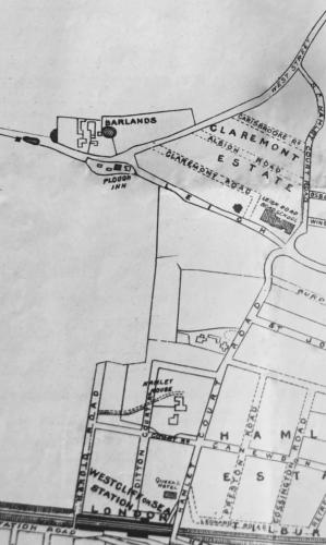
c1897 Map, location of the Plough P.H.
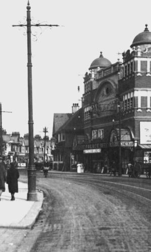
The Palace Theatre & the Plough P.H.


Southend-on-Sea’s No 1 History Website! Documenting The Town & The Townspeople

Now Incorporating The Sea Of Change Website
Website Info:


Chalkwell ▪ Eastwood ▪ Leigh-on-Sea ▪ Prittlewell ▪ Shoeburyness ▪ Southchurch ▪ Thorpe Bay ▪ Westcliff-on-Sea


SOUTHEND CITY


