Prittlebrook
In
the
mid
60s
a
survey
of
the
Prittlebrook
was
made
to
identify
its
course;
this
feature
is
a
summary
of
the
work
and
makes
fascinating reading some fifty five plus years on.
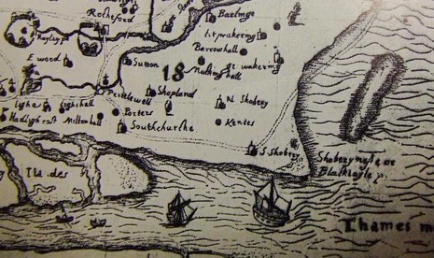
Reference
to
the
Ogilby
and
Morgan
map
of
Essex
(1678)
shows
a
river
flowing
due
east
from
the
south
of
Eastwood
and
turning
due
north
at
Prittlewell
Priory
to
join
the
River
Roach
east
of
Rochford.
It
is
familiar
knowledge
that
the
Roach
joins
the
Crouch
via
the
salt
marshes
of
the
hundred
and
thence
flows
into
the
North
Sea.
The
map
of
Essex
by
Joannes
Blaeu
(1645)
fails
to
show
the
Prittlebrook
flowing
from
the
west;
it
appears
to
start
near
Porters.
John
Norden’s
map
of
Essex
(1594)
shown
right,
which
I
believe
is
the
oldest
map
we
have
of
the
county,
shows
a
river
of
considerable
size
flowing as portrayed in the 1678 map.
Comparisons
with
modern
Ordnance
Survey
maps
–
6in,
21/4in
and
1in
to
the
mile-
make
one
wonder
what
the
course
of
the
Prittlebrook
really
is
or
was:
people
will
say
“The
brook,
you
know,
comes
all
the
way
from
London”;
or
“it
rises
at
Ilford
(or
maybe
Wickford)”
etc.
Now
we
know
that
Prittlewell
village
has
existed
since
pagan-
Saxon
times,
and
it
may
be
that
its
former
name
of
Prytilswielle,
meaning
spring
or
stream
of
Prytil,
is
derived
from
a
surname
Pritel.
Also
it
has
been
assumed
that
the
spring
of
the
smaller
of
the
two
ponds
within
Priory
Park
was
the
origin
of
the
brook.
During
the
latter
part
of
the
Roman
occupation
in
Britain,
Saxons
raiding
the
district
in
flat-bottomed
boats
may
have
reached
Prittlewell
via
Porter’s
Creek
(Blaeu
1645
map)
or
via
the
Roach
and
Prittlebrook.
It
was
in
the
twelfth
century
that
Robert
Fitzsweyn
founded
the
priory
of
Prittlewell
as
a
residence
for
the
monks
of
the
order
of
Cluny
in
France
and
as
a
cell
of
Lewes.
This
must
have
had great influence on the Prittlebrook.
With
some
of
these
points
in
mind,
the
junior
sections
of
the
South
Essex
Natural
History
Society
decided
to
trace
the
present
course
of
the
Prittlebrook
from
Thundersley
and
Hadleigh
to
the
Roach
near
Stambridge.
The
following
account
sets
out
exactly
what
we
discovered
between
September
1963
and
April
1964
in
a
series
of
Saturday
afternoon
primary
surveys.
Reconnaissance
work
was
undertaken
at
odd
times,
facilitate
transport
and
to
divide
up
the
course
in
a
practical
manner.
Throughout
the
brook
has
a
gravel
silt
base
and
contains
water
which
is
clear
and
neutral
to
slightly
alkaline
and
which
flows
at
speeds
varying
from
.55ft
per
second
to
5.6ft per second when in flood. At Sutton the salinity is .074 gms per cc.
Near
the
Thundersley
reservoirs
and
between
Little
and
Great
Commons,
in
heavy
rainfall
there
occurs
a
very
large
puddle
in
a
small
copse.
The
depth
is
only
about
six
to
nine
inches
and
the
overflow
is
via
Common
Lane
ditch;
very
soon,
however,
the
water
is
conduited
under
newly
built
houses,
but,
as
the
2
¼
in
map
indicates,
the
water
flows
downhill
south-east
and
south
to
the
Rayleigh
bridge.
Just
west
of
the
bridge
this
conduited
water
joins
up
with
a
very
small
river
flowing
east
after
having
made
a
right-angled
bend
as
it
descended
from
the
main
London
Road
at
Hadleigh,
at
the
back
of
the
houses
in
Cranbrook
Road,
at
a
height
of
225
feet.
We
think
that
this
latter
source
is
a
man
made
drainage
ditch.
Our
researches
have
necessitated
walking
in
the
water,
crawling
through
thickets
and
entering
gardens
and
houses
on
the
estate.
We
think,
too,
that
subsidiary
tributaries
arise
on
the
Thundersley
church height, but this has still to be investigated.
After
passing
under
Rayleigh
Road,
the
brook
flows
steadily
eastwards
through
West
Wood
to
Dawes
Heath
Road.
The
wood
forms
a
beautiful
setting,
but
it
is
not
always
easy
to
follow
the
river
as
parts
are
now
conduited
because
of
recent
house
building.
After
Dawes
Heath
Road
the
river
gurgles
alongside
some
gardens
in
a
steep-sided
meandering
course.
It
borders
agricultural
land
to
the
north,
then
passes
through
Dodd’s
Grove,
a
copse
of
the
local
nature
reserve,
to
Poors
Lane.
This
is
a
really
lovely,
unspoilt
part
of
the brook.
Still
meandering
and
flowing
eastwards
the
brook
borders
the
north
side
of
the
major
part
of
the
nature
reserve,
receiving
two
tributaries
from
the
southern
watershed;
but
it
turns
south
east
and
south
as
it
approaches
Agnes
Avenue
and
the
golf
links.
A
prattling
tributary
from
Highlands
on
the
south
west
joins
the
brook
just
before
Agnes
Avenue
Bridge,
and
here
man
has
recently
straightened
and
concreted
the
floor
and
sides
of
the
brook.
The
result
has
been
the
formation
of
an
artificial
“ox-bow
lake.”
Probably
the
concreting
has
helped
the
brook
flow
better
in
times
of
flood
water
as
it
courses
in
an
easterly
direction
to
Eastwood
Road. All along here the trees are really beautiful.
From
Eastwood
Road
to
Victoria
Avenue,
Prittlewell,
the
brook
flows
in
an
easterly
course
and
is
concreted
most
of
the
way.
There
is
one
conduited
tributary
from
the
south-west,
and
although
the
brook
flows
between
the
dwellings
of
a
built
up
area
all
along
Manchester
Drive
and
Fairfax
Drive
one
can
walk
along
its
course
by
means
of
a
beautiful
tree-lined
path
for
some
two
and
a
half
miles.
There
are
eighteen
road
bridges
for
the
young
to
crawl
under.
The
Essex
River
Board
tries
to
prevent
dumping
of
rubbish
by
notice
boards
carrying the threat of fines, but it is not entirely successful.
At
last
our
brook
enters
the
beautiful
Priory
Park,
meanders
some
twelve
times,
connects
up
with
the
two
fish
ponds,
bends
east-north-east
and
in
an
obviously
artificial
straight
course
reaches
Priory
Crescent
(a
main
road).
Traces
of
the
original
bend
and
course
are
visible
by
the
little
stone
bridge.
In
the
Ekco
forecourt
are
a
weir
and
the
concreted
sides
which
made
an
ARP
fire-
fighting
reservoir
in
World
War
II.
In
four
drainage
pipes
from
the
factory
live
the “wild cats” with their canteen bins and water close to hand.
Permission
was
readily
granted
to
follow
the
brook
through
Ekco,
under
the
railway
alongside
the
sewage
works
(where
again
the
river
has
been
straightened
as
it
flows
northwards,
to
allow
a
huge
dust-heap
to
be
tipped)
and
over
the
Sutton
fields
of
the
farmer,
Mr
Alec
Steel,
where
beautiful
meanders
run
naturally
and
lovely
trees
and
birds
were
found.
Then,
at
the
last
meander,
the
river
becomes
tidal
and
has
dyke
walls
to
Sutton
Road
Bridge
and
beyond,
where,
at
Fleet
Hall
Farm,
we
saw
it
join
the
River
Roach
opposite Stambridge mill.

Southend Timeline Southend-on-Sea © 2009 - 2024. All Rights Reserved

By Phyllis M. Taylor MA, FLS


Website Info:

Southend-on-Sea’s No 1 History Website! Documenting The Town & The Townspeople
Now Incorporating The Sea Of Change Website


SOUTHEND CITY
Chalkwell ▪ Eastwood ▪ Leigh-on-Sea ▪ Prittlewell ▪ Shoeburyness ▪ Southchurch ▪ Thorpe Bay ▪ Westcliff-on-Sea


