Queensway
The Plan
First
plans
for
the
Southend
town
centre
by-
pass
were
debated
in
1961,
however,
the
talks
dragged
on
and
it
would
not
be
until
1966
when
work
finally
began
on
the
northern
part
new
roadway
scheme
skirting
the
High
Street.
The
High
Street
traffic
had
become
extremely
busy
especially
for
through
traffic
at
the
Victoria
Circus
junction.
The
idea
was
to
direct
traffic
away
from
the
area
ready
for
a
new
shopping
centre
and
pedestrianisation
of part the High Street for shoppers.
In
December
1965
the
Ministry
of
Transport
made
a
grant
of
£869,986,0s,0d
towards
the
cost
of
the
northern
section
and
part
of
the
eastern
section,
the
total
estimated
cost
of
the
northern
&
eastern
sections
was
put
at
£2,000670,0s.0d.
Plans
were
advertised
and
the
council
asked
contractors
to
submit
their
tenders
for
consideration,
the
closing
date
was
Friday
28th
January
1966.
The
planning
application
submitted
by
City
of
London
Real
Property
Company
&
British
Railway
Board,
gained
planning
approval
on
3rd
March
1966,
however,
whilst
the
walkway
and
shopping
centre
were
constructed
the
redevelopment
of
Victoria
Railway
Station
never
took
place
although
the
original
building
has
been refurbished over the years.
North & East Section
The
north
and
east
section
of
the
new
road
was
the
joining
of
several
roads
and
making
them
into
a
dual
carriageway.
Starting
at
London
Road
it
incorporated
Dowsett
Avenue
up
to
it’s
junction
with
Victoria
Avenue,
it
then
went
on
past
the
then
proposed
Victoria
Circus
roundabout
into
Bradley
Street
and
into
Prittlewell
Street,
the
route
would
then
carry
on
down
Prittlewell
Street
(renamed
Bradley
Street)
to
join
up
with
Porters
Grange
Avenue,
where
it
would
run
past
the
railway
bridge
that
crosses
over
the
road
into
Bankside,
following
into
Corsham
Road
and
into
Darnley
Road
at
the
roundabout
outside
the
Seaway
car
park,
it
would
then
swing
left
and
finally
end
at
the
roundabout
at
the
junction
with
Woodgrange
Drive
and
Southchurch Avenue.

Southend Timeline Southend-on-Sea © 2009 - 2024. All Rights Reserved

Southend-on-Sea
Queensway Construction
The
by-pass
was
designed
and
laid
as
a
two-lane
each
way
road
with
an
extra
wide
central
reservation,
its
design
allowed
expansion,
if
demand
later
required
an
extra
lane
this
could
easily
be
achieved
in
each
direction
by
reducing
the
width
of
the
central
reservation. The estimated cost of the new road was put at £12million.
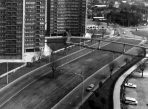
The
new
dual
carriageway
was
not
easy
for
pedestrians
to
cross,
so
an
“overbridge”
with
shops
was
constructed
for
people
to
cross
from
Southend
Victoria
Railway
Station
to
the first floor of the new shopping development at Victoria Circus.
In
April
1966
a
number
of
trees
that
had
suffered
from
root
damage
during
the
construction
of
the
ring
road
were
removed,
it
was
stipulated
that
they
had
to
be
replaced
on
a
one
for
one
basis
with
the
replacement
trees
being
located
within
the
ring
road scheme area.
In
October
1973
the
Government
released
75%
of
the
funding
needed
to
buy
up
buildings
and
land
in
advance
of
the
construction
of
the
eastern
section
of
the
road
that
was
to
run
south
of
Bankside,
the
southern
section
spur
to
Woodgrange
Drive/Southchurch Avenue.
The
development
of
what
would
become
Queensway
was
holding
up
the
pedestrianisation
of
the
High
Street,
because
of
traffic
reasons
the
section
between
Hotel
Victoria
and
Warrior
Square
South
had
to
wait
until
the
first
section
of
the
Ring
Road
had
been
completed
and
opened.
The
roads
incorporated
in
the
scheme
all
kept
their
own
identities
until
Queen
Elizabeth's
1977
Silver
Jubilee
when
the
entire
length
of
the
road
was
re-named
Queensway,
this
also
saw
the
opening
of
the
£1million
underpass section at the Southchurch Road/Sutton Road junction.
Property Acquisition
Because
of
the
size
of
the
project
and
the
fact
many
private
dwellings
sat
directly
in
the
way
of
the
proposed
roadway
the
council
had
to
rely
on
Compulsory
Purchase
Orders
(CPO)
to
buy
up
the
houses
and
shops
to
enable
the
road
to
be
constructed,
between
1965
&
1966 a number of properties had been purchased by the council with the CPO's including:
July 1965
43 & 103 Porters Grange Avenue.
November 1965
15 & 15a Dowsett Avenue, 20 & 48 Milton Street, 38 Porters Grange Avenue, 12 Prittlewell Street, 34 Sutton Street.
February 1966
9
&
41
Dowsett
Avenue,
Essex
Garage
Essex
Street,
4,
14,
22,
24,
26,
28,
62,
64
&
68
Milton
Street,
49
Porters
Grange
Avenue,
52
Prittlewell Street.
April 1966
23
&
39
Dowsett
Avenue,
34
&
36
Milton
Street,
52
Prittlewell
Street,
141,
143,
147,
155,
165
&
169
Southchurch
Road,
33,
35
&
43
Sutton Street.
June 1966
11 & 31 Dowsett Avenue.
September 1966
27, 29 & 33 Dowsett Avenue.
June 1971
321 Southchurch Road, 51 & 52 Porters Grange Avenue, 104 - 109 Porters Grange Avenue.
September 1973
T. A. Centre Corsham Road demolished.
October 1973
62 & 64 Darnley Road demolished.
April 1975
Porters Grange Avenue service station purchased.
Houses
bought
up
by
the
council
were
quickly
boarded
up
while
they
awaited
demolition,
some
were
already
in
a
state
of
dilapidation and were quickly demolished.
NOTE. This section will be updated as and when further details are found.
Dowsett
Avenue
to
Victoria
Avenue
(London
Road
to
Victoria
Avenue)
The
Dowsett
Avenue
section
of
the
by-pass
(Queensway)
starts
at
a
newly
formed
junction
at
London
Road
it
sweeps
in
a
gentle
progressing
curve
to
the
Victoria
Gateway (Victoria Circus) junction at Victoria Avenue.
Whilst
the
name
Dowsett
Avenue
was
chosen,
the
ring
road
is
actually
on
a
slightly
different
alignment
to
the
original
Dowsett
Avenue,
however
the
name
has
historical
links
to
town.
Thomas
Dowsett
was
a
local
business
man
who
became
the
first
Mayor
of
Southend
in
1892,
he
was
also
an
estate
agent
and
developer
he
built
many
properties
in Southend including the listed Clifton Terrace.
Victoria
Gateway
was
originally
know
as
Victoria
Circus,
as
well
as
the
more
recent
name
change
the
site
of
Victoria
Circus
has
also
moved.
It
was
originally
located
about
420ft
further
South
than
its
current
position.
The
original
position
put
it
outside
the
old
Dixons
Department
Store
(now
W.
H.
Smiths),
Talza
Arcade
(demolished
and
replaced
by
the Victoria Shopping Centre, Victoria Plaza) and the Technical College (demolished and replaced by the Odeon Multiplex Cinema).
The
new
ring
road
also
saw
the
bisecting
of
Boston
Avenue,
the
two
sections
could
not
be
more
different.
The
main
remaining
section
is
some
1732
ft
long
it
is
lined
with
houses
and
the
St
Mary's
Prittlewell
Church
of
England
Primary
(formerly
Dowsett
High
School
for
Girls).
The
the
cut
off
piece
is
not
more
than
90ft
long
and
doesn't
retain
the
Boston
Avenue
name,
it
just
an
access
slip
road
for
the
businesses
that
operate
there,
this
section
of
Boston
Avenue
was
originally
called
Edward
Road,
this
small
section
ran
from
London Road to the junction with Dowsett Avenue, it was such a small stretch road it became absorbed into the larger road.
To
reduce
the
risk
of
flooding
on
the
new
ring
road
the
Dowsett
Avenue
section
of
the
new
road
saw
a
£54,000
surface
water
drainage system installed.
Bradley Street/Prittlewell Street to Southchurch Road/Porters Grange Avenue
After
leaving
the
relocated
Victoria
Gateway
(Victoria
Circus)
the
ring
road
followed
the
line
of
Bradley
Street
before
sweeping
gently
into
what
was
Prittlewell
Street,
this
whole
section
was
named
Bradley
Street.
The
name
Prittlewell
Street
was
not
entirely
lost
one
small
section
survives
as
a
residential
street
to
this
day.
A
public
footbridge
was
also
included,
this
connected
a
housing
estate
to
Queensway House and the Victoria Shopping Centre/Victoria Plaza.
Further
down
Bradley
Street
a
new
public
footbridge
was
built
over
the
ring
road
this
connected
a
housing
estate
to
Queensway
House and the Victoria Shopping Centre.
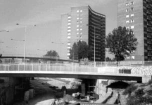
Porters Grange Avenue into Bankside
In
December
1973
the
Department
of
Environment
awarded
a
grant
of
£869,223
totalling
75%
of
the
estimated
£1,194,964
total
cost
of
the
works
to
restructure
the
roadway
between
Southchurch
Road
roundabout
&
Bankside
taking
in
Porters
Grange
Avenue.
The
works
included
widening
the
road
and
building
the
underpass.
Further
works
on
the
area
saw
an
injection
of
funds
of
£837
for
the
realignment of Sutton road.
Originally
Bradley
Street
section
of
the
by-pass
(Queensway)
ran
directly
to
a
roundabout
at
the
junction
of
Southchurch
Road
and
Porters
Grange
Avenue,
however,
a
few
years
after
completing
the
road
a
new
underpass
and
roundabout
was
constructed,
the
underpass
would
enable
quick
and
easy
unimpeded
access
to
Porters
Grange
Avenue,
for
traffic
travelling
along
the
by-pass
towards
the
seafront,
whilst
traffic
wishing
to
access
Southchurch
Road
or
Sutton
Road
could
use
the
roundabout
over
the
top.
A
public
subway
and
footbridge
was
included
at
the
junction
to
help
those
on
foot.
A
second
pedestrian
underpass
was
included
further
down
this
section
opposite Grange Gardens
The
new
ring
road
also
cut
Milton
Street
in
two,
the
section
south
of
the
ring
road
(outside
the
Victoria
Shopping
Centre
running
to
the
bus
station)
was
renamed
Chichester
Road,
the
remaining
section
retained
it's
name,
however
it
was
not
connected to the ring road.
Bankside into Corsham Road
Porters
Grange
Avenue
ended
at
the
railway
bridge
taking
the
London
Tilbury
and
Southend
Railway
over
the
ring
road.
The
other
side
of
the
bridge
was
known
as
Bankside,
this
was
by
far
the
shortest
section
of
the
ring
road
for
as
soon
as
Bankside
started
Bankside
ended!
however,
as
the
bridge
had
been
built
long
before
the
road
had
been
proposed
it
was
only
wide
enough
to
handle
a
single lane in either direction and two footpaths, the bridge needed to be lengthened.
On
the
17th
September
1970
an
agreement
was
reached
with
British
Rail
to
transfer
the
land
needed
to
extend
the
railway
bridge
so
that
the
new
ring
road
could
pass
underneath
it.
The
work
to
lengthen
the
railway
bridge
started
in
December
1973
and
was
forecast
to
take
18months
to
complete,
during
the
construction,
a
one-way
system
was
implemented
southbound
between
Whitegate
Road
and
Portland
Avenue,
two
way
traffic
was
maintained
on
Porters
Grange
Avenue,
existing
parking
bays
on
the
road
were
also
closed
and removed from the ring road once it was completed. This section of the ring road was the shortest that retained its name.
Corsham Road into Darnley Road
Corsham
Road
ran
from
Bankside
to
York
Road,
but
to
enable
the
ring
road
to
be
constructed
a
number
of
private
dwellings
had
to
be
demolished,
York
Road
was
cut
through
and
is
now
in
two
distinct
sections,
however,
both
parts
retain
the
York
Road
name.
The
evidence
of
these
demolitions
can
still
be
seen in the buildings that were left.
To
reduce
the
number
of
possible
accidents
Portland
Road
that
had
always
run
into
Corsham
Road
was
closed
off
to
all
traffic
entering
or
leaving
the
new
ring
road,
access
is
now
only
possible
to
traffic
from
Baltic Avenue.
In
September
1973
the
Corsham
Road
T.
A.
Centre
was
demolished
to
clear
the
way
for
the
road
to
continue.
Darnley Road to Seaway Roundabout
Darnley
Road
ran
from
York
Road
down
to
the
Seaway
Roundabout.
On
Tuesday
21st
September
1937
a
special
meeting
of
the
then
Southend
Town
Council
agreed
to,
purchase
4.65
acres
of
land
laying
either
side
of
Seaway
(a
road
leading
from
Darnley
Road
to
Hartington
Road)
from
the
trustees
of
the
late
Mr.
Alfred
Tolhurst
for
the
sum
of
£31,000.
The
land
was
purchased
by
the
Council
due
to
the
growing
need
to
create
car
parking
facilities
in
the
vicinity
of
the
seafront
and
pier.
The
sale
was
agreed
without
any
restriction
placed
upon
the
land,
this
would
enable
the
Council
to
construct
Southend’s
first
Municipal
car
park,
giving
the
town
a
new
stream
of
revenue
income,
and
taking
as
many
as
500
cars
away
from
the
free
street
parking.
The
land
had
previously
been
used
as
a
car
park
but
had
never
been
laid
out
for
such
use,
it
was
thought
that
if
the
Council
did
not
buy
the
land
other
interested
parties
would
buy
the
land
and
set
up
their
own
car
park
thus depriving the Council of the income it could generate.
Traffic
would
grind
to
a
halt
during
the
summer
and
illumination
seasons,
as
cars
would
trawl
the
streets
looking
for
a
parking
space,
the
belief
a
large
car
park
just
off
the
seafront
would
help
alleviate
the
pressure
of
the
narrow
residential
streets
close
to
the
seafront.
It
was
also
possible
that
the
land
could
in
future
be
developed
to
generate
new
tourist
facilities,
the
land
was
acquired
and
a
car
park
was
built.
The
Council
bought
what
land
was
available
however
it
was
not
until
April
1974
that
all
the
land
had
been
acquired
with
a
section
between
the
Seaway
Car
Park
and
78
Darnley
Road
being
one
of
the
last
remaining
sections to be acquired.
The
car
park
was
at
the
centre
of
a
major
planning
application.
Major
plans
for
the
development
of
a
£50
million
leisure
and
residential
scheme
at
Seaway
car
park.
The
proposals,
which
would
transform
the
land
near
to
the
seafront
at
Lucy
Road,
include
a
ten-screen
cinema,
eleven
restaurant
units
and
a
99-apartment
residential
scheme.
A
480
space
multi-storey
car
park
is
also
planned
to
replace
the
current
453
space
surface
parking.
Also
included
in
the
plans
is
the
site
of
the
former
Rossi
Ice
Cream
Factory
and
Number
29,
Herbert
Grove,
which
were
purchased
by
the
Council
in
2008,
to
enable
future
regeneration
in
a
deal
funded
by
the
Homes
and
Communities
Agency
which
is
fully
supportive of the proposed development.

Seaway Roundabout to Southchurch Avenue/Woodgrange Drive
The
final
section
of
the
ring
road
is
a
section
that
many
people
forget
is
still
actually
part
of
the Queensway.
This
section
leads
from
the
Seaway
roundabout
to
the
roundabout
at
the
junction
of
Southchurch
Avenue
and
Woodgrange
Drive,
this
section
enables
traffic
to
access
the
seafront
at
the
Kursaal,
head
up
Southchurch
Road
or
access
Woodgrange
Drive
to
Thorpe
Bay and Shoebury. This short section of Queensway is a single lane in either direction.
The Tesco Proposal
The
B&Q
DIY
chain
moved
out
of
the
building
off
Short
Street
and
moved
to
a
new
purpose
built
£3
million
superstore
at
Fossetts
Farm
which
opened
on
Friday
27th
July
2007.
The
old
Short
Street
building
was
30,000
square
foot,
the
replacement
was
150,000
square
foot,
the
new
gardening
section
alone
matching
the
size
of
the
old
building!
The
old
Short
Street
building
sat
empty,
and
soon
became
a
target
for
vandals
and
the
graffiti
artists.
Pre-empting
the
relocation
of
B&Q
to
Fossetts
Farm
it
was
reported
that
Tesco
had
made
an
offer
for
the
Royal
Mail
Short
Street
sorting
office.
The
report
said
that
an
initial
offer
for
£10
million
had
been
rejected
a
second
offer
included
the
construction
of
a
replacement
sorting
office
in
Priory
Crescent,
it
was
said
that Royal Mail had no plans to vacate the Short Street site.
In
January
2008
news
that
Tesco
wanted
to
create
a
department
store
on
the
old
B&Q
site
was
bounding
about
the
town.
Tesco
announced
that
it
had
indeed
bought
the
B&Q
site
and
were
evaluating
it
for
a
“multi-use
&
retail”
development.
In
March
2008
£150
million
plans
were
revealed
for
a
major
redevelopment
of
the
B&Q
site,
these
plans
were
for
a
multi-storey
building
covering
83,000
sq
ft,
raised
on
stilts
to
permit
space
for
900
cars
below,
a
skyway
walk
would
link
it
directly
to
the
Victoria
Shopping
Centre/Victoria
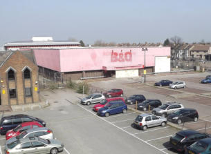
Plaza,
plans
also
included
272-flat
tower
block
and
20
family
houses
allocated
as
affordable
housing,
the
proposals
also
predicted
600
jobs
would
be
created.
In
June
2009
with
the
credit
crunch
hitting
a
high,
Tesco
announced
it
would
be
submitting
revised
plans,
this
included
scrapping
the
proposed
flats,
and
redesigning
the
store
proposals
with
the
recession
to
blame
for
the
redrawing
of
the
proposals
saw
the
square
footage
reduced
by
a
quarter
and
the
proposed
jobs
cut
to
450.
The
revised
plans
were
formally
submitted
to
the
Council
in
June
2010,
the
changes
retained
the
bridge
linking
the
new
store
to
the
Victoria
Shopping
Centre/Victoria
Plaza
and
a
replacement
for
the
Focus
Youth
Centre.
The
changes
to
the
application
included
a
reduction
in
the
number
of
parking
spaces
to
540m
with
90
cycle
stands,
all
traffic
would
use
Short
Street
to
access or exit the site.
In
November
2011
the
big
vote
took
place
on
the
proposals,
the
development
was
passed
by
the
Council,
a
“barrier”
system
was
to
be
included
to
enable
a
better
flow
of
traffic
into
and
out
of
the
car
park,
electronic
signs
informing
drivers
of
the
state
of
the
car
park
were
also
included
as
a
provision
of
the
approval,
a
charging
system
was
also
part
of
the
approval
were
people
using
the
car
park
and
not
shopping
would
have
to
pay
a
parking
fee
whilst
shoppers
would
be
able
to
redeem
the
cost
of
parking.
A
contract
drawn
up
between
Tesco
and
the
Council
included
a
financial
deal
where
Tesco
would
pay
£50,000
towards
new
cycle
routes,
£120,000
for
public
art
and
£42,000
towards
an
extension
of
the
CCTV
network.
Despite
the
approval
no
work
begun
on
the
site
and
in
December
2012
dark
clouds
of
doubt
began
gathering
over
the
site,
as
Tesco
was
beginning to shy away from the large scale supermarkets.
In
June
2013
the
news
that
everyone
was
half
expecting
came
out
that
Tesco
was
scrapping
the
Short
Street
scheme,
the
retailer
was
carrying
out
a
major
strategy
review
into
its
core
business
practices
relating
to
the
larger
superstores
and
the
smaller
local
stores.
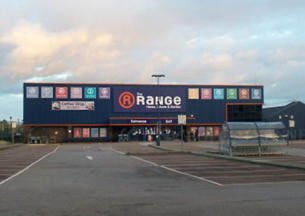
In
August
2013
it
was
announced
that
the
home
and
garden
retailer
the
Range
were
looking
at
Southend
for
a
new
store.
The
retailer
soon
announced
that
the
old
B&Q
store
was
in
the
prime
location
and
soon
set
about
renovating
the
old
store
into
a
modern fresh retail unit. The new store opened on 29th November 2013.
Residential Development
With
a
large
number
of
residential
properties
being
demolished
to
make
way
for
the
new
ring
road
a
way
of
replacing
them
needed
to
be
put
in
place,
thought
also
had
to
be
given
to
the
expected
growth
in
the
population
in
future
years.
A
major
limiting
factor
on
what
could
be
done
to
replace
the
building
being
demolished
whilst
not
encroaching
on
the
ring
road
development
site
was
the
lack
of
building
space
within
the
town
centre
area,
demolition
work
saw
whole
streets
lost,
with
Prittlewell
Street
loosing
three
quarters
of
its length.
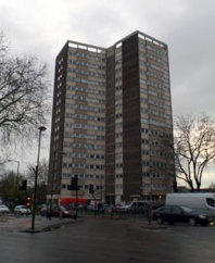
The
redevelopment
proposed
to
include
three
16
storey
tower
blocks
on
what
was
Prittlewell
Street
with
a
fourth
on
the
other
side
of
the
ring
road.
The
£1,360,000
project
was
scheduled
to
take
124
weeks
to
build,
with
John
Lang
Construction
chosen
to
undertake
the work. There was a total of 176 Bored Pile foundations up to 42.5 foot deep sunk into the ground to support the new buildings.
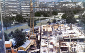
The
four
new
tower
blocks
were
at
the
time
the
tallest
buildings
in
Southend,
they
were
set
upon
columns
lifting
them
above
ground
level
so
that
car
parking
and
garages
could
be
laid
out
for
a
total
of
436
cars.
There
were
417
flats
included
in
the
scheme,
made
up
of,
240
two
bedroom
flats,
the
rest
for
elderly
made
up
from
120
single
bedroom
&
57
bed
sits.
The
four
blocks
were
interconnected
by
walkways
at
1st
floor
level
with
a
footbridge
over
the
new
ring
road
linking
to
the
High
Street,
a
laundry
block
was
included
a
was
a
workshop
for
DIY
fans.
The
four
tower
blocks
were
named:
Quantock,
Pennine,
Chiltern
&
Malvern.
A
small
number
of
two
storey
town houses were also included on the Southchurch Avenue side of the site.
Queensway House
Queensway House was built in the 1970s and was home to a number of Council and health care facilities.
The
building
was
constructed
of
brick
and
reinforced
concrete,
it
was
connected
to
the
Victoria
Shopping
centre/Victoria
Plaza
by
a
footbridge
over
Chichester
Road
with
a
second
footbridge
over
Queensway
ring
road,
there
was
also
a
multi-storey
car
park
underneath.
As
Council
services
relocated
elsewhere,
the
building
become
less
used,
it
was
announced
that
the
last
of
the
service
provided
from
the
building
would
be
moved
out
in
March
2013,
and
that
the
building
would
be
demolished
in
preparation
for
the
redevelopment
of
the
area.
Until
such
time
funding
and
a
full
plan
of
the
regeneration
could
be
drawn
up,
the
site
would
become
a
public single level car park opening for the first time on Friday 12th September 2014.
Defending the Queensway
During
the
Second
World
War
the
roads
that
were
to
become
the
new
ring
road
were
a
twisting
and
turning
maze,
the
Dowsett
Avenue
&
Victoria
Avenue
junction
was
a
vital
artery
to
defend
and
slow
any
advance
from
any
possible
invasion
from
German
troops.
To
slow
any
advance
the
junction
was
covered
by
two
pillboxes,
one
was
located
on
the
junction
of
Victoria
Avenue
&
Dowsett
Avenue,
the
second
was
located
just
inside
the
grounds
of
the
Municipal
College,
a
number
of
anti
tank
blocks
were
also
situated
around
the
junction.
Further
pillboxes
were
dotted
around
the
London
Road
side
of
the
Municipal
College.
The
junction
still
remains
a vital artery but without the risk of invasion its much more open and free flowing without the need for defence structures.
Buses on Queensway
Long
before
the
construction
of
the
ring
road,
buses
used
London
Road
running
parallel to Dowsett Avenue.
Westcliff
Motor
Services
opened
a
bus
depot
at
no
33
London
Road
in
1922
to
house
their
fleet,
with
an
ever
growing
operation,
by
1933
it
was
decided
to
expand
the
depot,
WMS
purchased
Browns
Garage
at
no
35
London
Road
which
enabled
them
to
expand
their
services.
With
further
growth
no’s
17/21
were
acquired
by
WMS
and
construction
started
on
a
new
depot
linked
behind
the
intermediate
buildings opened on 2nd September 1937.
The
depot
remained
with
its
entrance/exit
only
opening
on
to
London
Road
until
the
construction
of
the
ring
road,
to
make
space
for
the
ring
road
and
bus
depot
the
22
houses
on
the
south
side
of
Dowsett
Avenue
were
demolished
so
that
a
new
entrance
could
be
created
with
the
London
Road
side
becoming
the
exit,
the
new
layout officially opened in June 1968.
The
depot
remained
operating
until
it
was
officially
closed
down
on
27th
June
1987,
the
depot
moved
to
Fairfax
Drive.
The
bus
station
was
demolished
and
a
Sainsburys
superstore was built in its place, the new store opened in March 1989.
Lost Roads & Shorter Streets
The
new
ring
road
originally
saw
each
section
keep
its
original
name,
however,
as
already
mentioned
the
Queensway
name
was
applied
to
mark
Queen
Elizabeth's
1977
Silver Jubilee.
A
number
of
other
roads
were
also
lost
these
were
swallowed
up
by
the
construction
of
the
Queensway
Housing
Estate
development
that
includes
the
Quantock,
Malvern,
Pennine and Chilton high-rise blocks.
The
roads
that
no-longer
appear
on
road
maps
of
Southend
include:
North
Street,
Lambert
Street,
Sutton
Street
&
Station
Approach.
Milton
Street
was
cut
in
two
by
the
new
road,
the
section
leading
to
and
from
the
bus
station
by
the
Royals
Shopping
Centre
became
Chichester
Road,
whilst
the
section
on
the
other
side
of
the
new
road
was
blocked
off
from
joining
the
new
ring
road,
the
parallel
running
Short
Street
slowly
developed
into
a
major
new
access
road
for
the
Royal
Mail
sorting
office
that
would
be
developed
in
future
years
followed
by
a
small
trading
estate.
Another
Road
effected
was
Essex
Street,
this
was
sliced
in
two
by
the
by-pass,
the
section
on
the
north
side
of
the
ring
road
was
covered
by
the
high-rise
flats
of
the
Queensway
Housing
Estate
and
the
ring road.
The
section
of
Essex
Street
on
the
South
side
of
the
ring
road
still
appears
on
maps,
the
road
was
realigned
after
the
construction
of
the
ring
road
so
that
it
absorbed
an
access
road
behind
the
shops
on
Southchurch
Road,
it
also
acts
as
a
route
to
the
new
Essex
Street car park, exiting on to Southchurch Road.
Prittlewell
Street
is
now
much
shorter
than
it
was
before
the
construction
of
the
by-pass,
much
of
it
was
absorbed
into
the
new
road
whilst
another
section
currently
sits
under
garages linked to the flats these were redeveloped for Social Housing.
Heritage
Street signs of the old roads.
Pocket Park
During
June
2014
work
started
on
installing
new
planters
at
Victoria
Gateway.
Also
work
begun
on
a
“Pocket
Park”
at
the
junction
of
Queensway
and
Boston
Avenue.
Works
to
create
the
Pocket
Park
included
moving
the
footpath
away
from
the
brick
wall
from
the
trees,
this
enables
the
trees
to
carry
on
growing
without
the
roots
damaging
the footpaths.
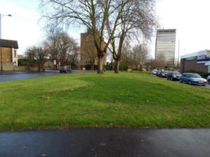
The
construction
of
the
new
Pocket
Park
meant
that
the
last
remaining
vestiges
of
the
original
Dowsett
Avenue
would
be
covered,
thus
bringing
a
small
piece
of
Southend
history to an end.
Future...
Further
plans
include
the
demolition
of
the
16
storey
“Quantock”
tower
block
with
residents
being
re-
housed
in
low-rise
buildings
built
elsewhere
in
the
town
or
in
converted
office
blocks
on
Victoria
Avenue,
further
ahead
plans
could
include
the
demolition
of
Malvern,
Pennine
and
Chilton
high-rise
blocks, and replacing them with low-rise homes.
Drawing
of
the
new
road
layout
showing
north,
east,
south
& west parts of ring road
Quantock High Rise
The
last
remaining
section
of
road
from
the
original Dowsett Avenue
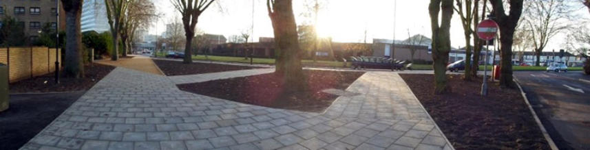
The new Boston Avenue/Queensway Pocket Park
At
the
entrance
of
Queensway
once
stood
a
road
sign
revealing
the
former name of that section
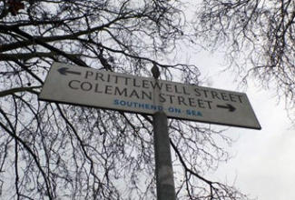
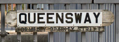
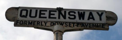
A
fading
road
sign
showing
the
"Formerly
Bradley
Street"
name,
the wooden part dates from 1977, now gone
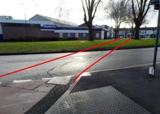
The
construction
of
the
Queensway
ring
road
saw
Boston
Avenue
sliced
in
two,
this
photo
shows
how
it
looks
today
with
the
two
red
lines
depicting
the
original line of Boston Avenue
The
last
remaining
section
of
the
original
Essex
Street
is
an
exit
route
from
the
rest
of
the
realigned Essex Street
Essex
Street
running
behind
the
shops
in
Southchurch Road
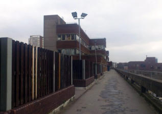
Closed
and
awaiting
demolition
Queensway
House,
in 2012
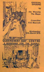
Opening day
programme for the
Queensway Day Centre
The
Range
store
early
on
the
morning
of
24th
December 2015
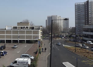
Queensway
Start/End
at
the
junction
of
Southchurch
Avenue
A1160
&
Woodgrange
Drive
The
Seaway
roundabout
links
the
Ring
Road
to Chancellor Road
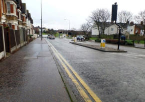
Darnley
Road
ran
from
its
junction
here
with
York Road down to the roundabout at Seaway
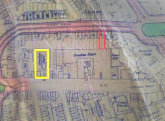
Map
of
the
area
redeveloped
for
the
bus
depot,
the
yellow
box
is
the
site
of
the
original
WMS
depot,
the
two
red
lines
designate
roughly
where
the
entrance
for the later bus depot was to be positioned
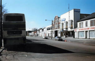
The
1922
Westcliff
Motor
Services
bus
depot
exit
on
to
London
Road,
is
the
grand
red
brick
building to the centre of the photo
The London Road exit from the 1968 bus depot
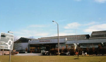
The
scene
today,
Sainsburys
and
its
car
park
which
replaced the bus depot
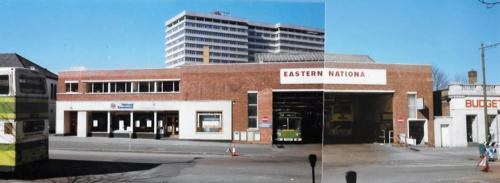
The
bus
depot
replaced
the
housing
that
lined
the
original
Dowsett
Avenue,
the
new
entrance
allowed
buses
to
enter
the
bus
station
from
Queensway
and
exit
on
to
London
Road,
a
works
and
maintenance
facility
was
included
in
the depot
Corsham
Road
runs
up
to
the
traffic
lights,
these
mark the separated junction at York Road
The
stopped-up
Portland
Avenue,
with
turning
bay
Two
houses
that
were
clear
of
the
new
ring
road
planned
route
these
were
luckier
than
their
adjoining
properties,
the
unusual
look
to
the
end
of
the
buildings
are
the
chimney
stacks.
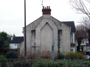
Evidence
that
there
was
once
more
to
the
building
than
there is today
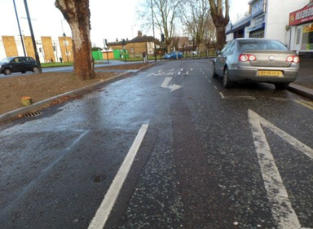
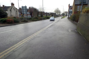
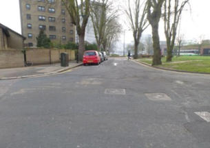
Street sign, the name of Prittlewell Street lives on
The last remaining section of Prittlewell Street
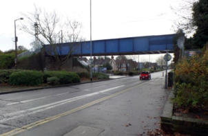
Footbridge
over
the
Bradley
Street
section
of
the
ring road
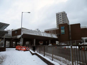
View
of
the
over-bridge
on
a
rather
cold
and
snowy
day
with
the
original
pedestrian
foot-way
still
separated
from
the
road,
the
shared
space
route follows the almost same route as the road
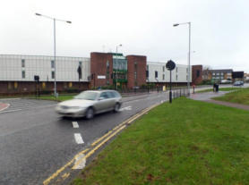
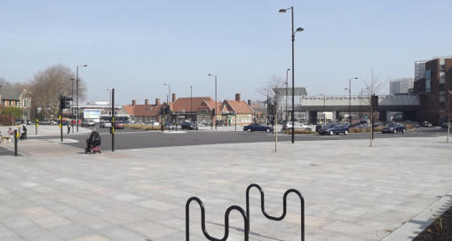
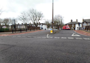
Victoria Circus to Victoria Gateway
As
part
of
the
Better
Southend
scheme,
Victoria
Circus
was
chosen
as
one
of
the
areas
that
would
benefit
from
the
scheme.
£7.5million
was
spent
completely
rebuilding
the
area,
the
roundabout
was
completely
removed
and
a
new
traffic
light
controlled
T
junction
was
constructed,
a
new
public
square
was
included
outside
Southend
Victoria
Railway
Station
which
included
one
of
the
first
Shared
Spaces
in
the
town,
this
enables
buses
to
avoid
the
traffic
lights
giving
them
a
clear
dedicated
route.
A
bus
interchange
was
included
under
the
over-bridge
giving
people
waiting
cover
from
the
rain.
Work
started
in
January
2010
and
area
was
officially
opened on 1st June 2011.
The
public
square
is
also
home
to
a
public
work
of
art
£50,000
bronze
sculpture
by
Belgian
artist
René
Julien,
The
Return,
depicts
two lovers reunited after time apart.
The
work
was
paid
for
out
of
a
grant
from
the
Government’s
Homes
and
Communities
Agency
as
part
of
a
project
to
revamp
Victoria
Gateway
Square,
the
statue
was
chosen
as
it
represents
what
the
location
is
all
about
people
return
home
to
their
loved
one
at
a
palace where pedestrians, cars, buses and trains all converge in one location.
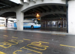
The bus interchange under the over-bridge
The Return
A
snow
covered
roundabout
during
the
works
to
replace it with a T junction, 10th January 2010
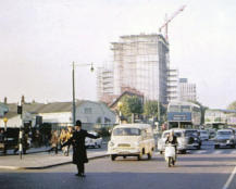
Policeman directing traffic at the
busy Victoria Circus junction
From
Victoria
Gateway
to
Porters
Grange
Roundabout
Construction of Porters Grange underpass
Empty B&Q building
Focus Youth Centre
1974 Construction of Queensway House
Victoria Gateway 2012
South & West Section
The
south
section
of
the
ring
road
was
planned
to
come
off
the
Seaway
roundabout
and
follow
Chancellor
Road,
it
would
have
carried
into
Grover
Street
where
a
new
roundabout
was
planned
linking
the
ring
road
to
the
High
Street,
the
southern
section
would
have
carried
on
along
from
the
new
junction
into
Royal
Mews
and
Richmond
Avenue,
then
would
gently
sweep
up
crossing
the
rear
yard
of
the
old
Alexandra
Street
Police
Station
before
merging
with
Alexandra
Road
at
its
junction
with
Capel
Terrace
and
Devereux
Road,
with
no
access
to
the
ring
road
from
Capel
Terrace
or
Devereux
Road
both
being
blocked
off
at
one
end.
From
Alexandra
Road
it
would
have
passed
the
southern
end
of
Cashiobury
Terrace,
where
it
would
turn
up
to
cross
the
southern
part
of
Runwell
Terrace
(both
being
closed
to
through
traffic),
before
heading
north
to
cross
Cambridge
Road.
The
road
would
then
have
been
built
across
Milton
Place
before
joining
the
western
section
at
Scratton
Road
railway
bridge,
the
western
section
would
of
continued
into
Hamlet
Road
head
north
up
Princes
Street
but
on
a
slightly
different
angle
and
finish
at
the
roundabout
at
London
Road
Dowsett
Avenue
junction
where
it
started,
this
would
have
seen
the
whole
demolition
of
the
western
side
of
Princes
Street
for
its
entire
length,
it
would
also
have
seen
the
demolition
of
the
southern
east
side
of
Park
Street.
It
was
quickly
established
that
having
a
dual
carriageway
slicing
through
the
High
Street
would
cause
major
problems
to
shoppers
and
visitors
arriving
at
the
train
stations
wanting
to
get
to
the
seafront.
A
new
plan
was
hatched,
the
answer
was
to
scrap
the
southern
section
of
the
ring
road,
and
instead
construct
an
underpass
at
the
northern
part
of
the
by-pass,
which
would
still
direct
traffic
away
from
the
High
Street.
Both
the
southern
and
western
sections
of
the
ring
road
were
scrapped
soon
after
work
had
started
on
the
project.
Many
properties
had
been
demolished
to
make
way
for
the
north
and
east
new
road
and
many
more
would
go
in
the
south and west sections, which meant falling numbers of people living along the route of the proposed section.
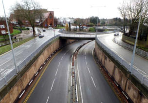
The
Deeping
underpass
was
constructed
as
part
of
the
Hammerson
Shopping
Centre
development
using
the
diaphragm
tunnelling
method,
this
would
see
the
site
dug
out
before
piles
were
driven
into
the
substrata,
a
base
was
then
laid
along
with
retaining
walls
before
the
site
was
capped
and
built
over.
It
was
estimated
that
the
cost
was
in
the
range of £220,000.
One
element
of
the
proposed
western
section
of
the
proposed
road
was
built
and
today
remains
as
a
single
solitary
element
of
the
greater
plan.
Before
the
western
section
was
scrapped
work
had
been
undertaken
to
double
the
width
of
the
Scratton
Road
bridge
that
crosses
the
railway
line
to
Fenchurch
Street,
it
was
widened
to
accommodate
the
new
ring
road,
these
alterations
remain,
with
the
bridge
twice
the
width
than
all
of
the
others
in
the
area,
whilst
the
bridge
is
wide
enough
to
carry
a
dual
carriageway,
it
is
restricted
to
a
single
lane
in
either
direction,
the
rest
of
the
road
is
given
over
to
a
cycle
path. None of the roads in this area were widened.
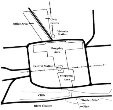
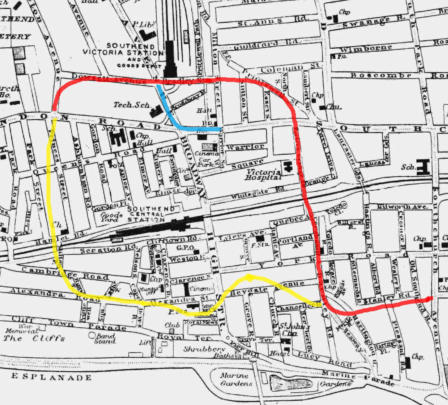
Map 1, before ring road. Map 2, proposed north (in
red
), south section (in
yellow
), underpass (in
blue
) route
Queensway’s wide central reservation
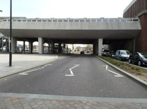
The
over-bridge
leading
to
the
shopping
centre,
providing
a
safe
way
to
cross
the
dual
carriageway
The
start
of
the
by-pass
(Queensway)
at
its
junction with London Road
Ring
road
sign
in
Dowsett Avenue
Bradley
Street
section
of
Queensway
before
the
under pass was built
The
underpass
on
what
was
Bradley
Street
that
takes
traffic
directly
under
the
junction
of
Southchurch
Road/Sutton
Road
traffic
would
emerge
on
to
the
Porters
Grange
Avenue
section
of the road
The
entrance
to
Porters
Grange
Avenue
section
is
dominated
by
the
bypass
roundabout,
it
includes
public subways and footbridge
The
railway
bridge
was
doubled
in
length
to
enable
it
to
accommodate
the
new
road
to
run
below
Standing
under
the
railway
bridge
where
Bankside
starts
the
end
can
clearly
be
seen
where Quebec Avenue joins the ring road
The
only
part
of
the
western
section
of
the
ring
road
to
be
built
was
the
widening
of
the
Scratton
Road railway bridge
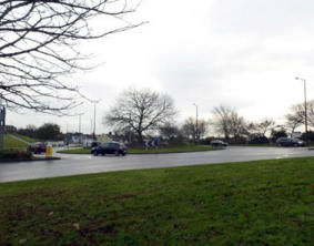
Chancellor
Road
as
it
is
today,
leads
from
the
Seaway
car
park
to
Church
Road
and
the
Royals Shopping Centre
The
remains
of
Boston
Avenue
(Edward
Road)
that is now an unnamed access road


Website Info:

Southend-on-Sea’s No 1 History Website! Documenting The Town & The Townspeople
Now Incorporating The Sea Of Change Website


SOUTHEND CITY
Chalkwell ▪ Eastwood ▪ Leigh-on-Sea ▪ Prittlewell ▪ Shoeburyness ▪ Southchurch ▪ Thorpe Bay ▪ Westcliff-on-Sea


