Seafront Defences
1939
saw
dark
clouds
of
war
gathering
on
the
horizon,
Southend
became
the
headquarters
of
the
Thames
and
Medway
Control.
The
Pier
was
taken
over
by
the
Royal
Navy
and
named
the
HMS
Leigh.
Southend’s
esplanades
became
areas
of
restricted
access
while
the
beaches had no access.
The
War
Office
had
seen
how
flat
the
Southend
foreshore
was,
the
gentle
slope
to
the
beach
leading
up
to
a
sloping
seawall
and
then
on
to
the
footpath
and
onto
the
road,
many
roads
coming
off
leading
to
the
heart
of
Southend
would
have
offered
any
invading
force
an easy way to encroach deep in land, setting up a beach head for further landing.
To
combat
this
problem
1804
concrete
anti-tank
blocks
were
erected
the
entire
length
of
the
seafront,
the
immense
task
saw
the
defence
stretch
3
1/4
miles
from
Chalkwell
Rail
Station
in
the
west
to
Thorpe
Bay
in
the
east,
the
1804
re-enforced
concrete
blocks
each
5ft
square
and
up
to
7ft
tall
weighed
in
at
several
tons,
in
between
each
block
was
strung
barbed
wire
to
repel
troops
on
foot,
the
beach
itself
was lined with scaffolding intertwined with more barbed wire
To
further
slow
any
invasion
each
and
every
road
leading
off
the
seafront
excluding
a
few
were
completely
blocked
off,
those
that
were
not
completely
blocked
were
set
up
as
check
points
and
in
the
event
of
a
landing
taking
place
a
Socket
Rail
Defence
could
be
locked
in
place,
these
type
of
defences
were
made
from
90lbs
off
cuts
of
steel
rails
or
RSJS
bent
to
create
a
"V"
shape,
they
were
given
the
nickname
"hairpins"
these
were
dropped
into
special
sockets
set
into
the
road.
Further
defences
included
concrete
pimples
and
concrete
pyramids
both
designed
to
stop
or
at least slow any tanks taking part in an invasion.
Once
war
was
over,
the
esplanades
and
surrounding
areas
were
gradually
restored
to
their
pre-war
condition,
two
concrete
blocks
and one pillbox avoided demolition and are still visible today.

Southend Timeline Southend-on-Sea © 2009 - 2024. All Rights Reserved

Road Defences
Chalkwell Esplanade
Chalkwell Avenue
Crowstone Road
Concrete Pimples
Concrete Pyramids & Socket Rail Defence
Western/Westcliff Esplanade
Cobham Road
Grosvenor Road
Palmerston Road
Pembury Road
Shorefields Road
Concrete Pimples
Concrete Pimples
Concrete Pimples & Socket Rail Defence
Concrete Pimples
Concrete Pyramids & Socket Rail Defence
Eastern Esplanade
Beach Road
Bryant Avenue
Burdett Road
Camper Road
Chelsea Avenue
Chester Avenue
Elizabeth Road
Hartington Road
Lifstans Way
Plas Newydd
Pleasant Road
Southchurch Road
Victoria Road
Concrete Pimples
Concrete Pimples & Socket Rail Defence
Concrete Pimples
Concrete Pimples
Concrete Pimples
Concrete Pimples
Concrete Pimples
Concrete Pimples
Concrete Pimples
Concrete Pimples
Concrete Pimples
Concrete Pimples & Socket Rail Defence
Concrete Pimples
Thorpe Esplanade
Broadway, The
Burges Terrace
Clieveden Road
Lynton Road
St Augustines Avenue
Thorpe Hall Avenue
Walton Road
Warwick Road
Concrete Pimples & Socket Rail Defence
Concrete Pimples
Concrete Pimples & Socket Rail Defence
Tubular Scaffolding
Anti-Tank Scaffolding
Concrete Pimples & Socket Rail Defence
Concrete Pimples & Socket Rail Defence
Tubular Scaffolding
Remains of the Clievden Road Socket Rail Defences
Remains of the Walton Road Socket Rail Defences
The
roads
leading
to
and
from
the
seafront
were
blocked,
the
esplanades
were
also
blocked
at
strategic
points
with
only
one
or
two
roads
available
for
access.
The
barriers
built
on
the
long
sweeping
seafront
road
were
designed
to
slow
any
invasion
force.
The
long
sweeping
seafront
road
would
be
used
to
establish
a
long
beach
head,
enabling
following
forces
to
spread
their
invasion
along
the
length of the seafront forcing the defending troops to spread their lines thin in an attempt to fight off the attack.
Esplanade Defences
Gasworks Jetty, Eastern Esplanade
160 Eastern Esplanade
50 yards east of the Halfway House
50 yards east of St Augustines Avenue
20 yards west of Shoebury Common Road
Top of beach Thorpe Slipway to beach huts
60 yards west of coastguard station
Concrete Pimples & Socket Rail Defence
Concrete Pimples & Socket Rail Defence
Concrete Pimples
Concrete Cubes & Socket Rail Defence
Concrete Pimples
Concrete Pimples
Concrete Pimples & Socket Rail Defence
Throughout
the
borough
more
than
70
roads
saw
some
kind
of
barrier
erected,
today
visible
evidence
of
these
defences
are
hard
to
find,
however
two
very
rare
surviving
examples
can
be
found.
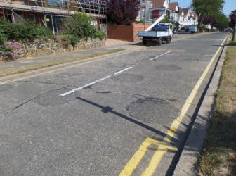
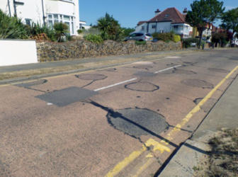
The
seaward
(southern)
ends
of
both
Clieveden
Road
&
Walton
Road
still retain markings in the road surface of the Socket Rail Defences.
Pillboxes
A number of pillboxes were also constructed along the length of the foreshore, these were mostly built on the beach.
Chalkwell bowling green
Chalkwell Crowstone Avenue
Southend Corporation Loading Pier
Southend Gas Works
Slipway Thorpe Esplanade
Hexagonal pillbox fitted with a six sided conical roof
Hexagonal pillbox fitted with a six sided conical roof
Bespoke design
Bespoke design built behind boundary wall
Hexagonal pillbox fitted with a six sided conical roof
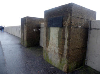
Apart
from
two
concrete
blocks,
another
survivor
of
perilous
times
is
a
pillbox
which
is
located
at
the
Premier
Inn
Hotel
(formerly
the
site
of
the
old
gasworks),
this
hidden
behind
a
curving
red
brick
wall,
a
single
brick
having
been
removed
from
the
wall
to
permit
a
firing position.
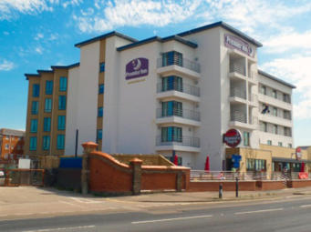
Hidden
behind
the
red
brick
wall,
curving
inwards
is
the last remaining World War 2 pillbox on the seafront
The
two
remaining
blocks
on
Eastern
Esplanade
opposite
the
Premier
Inn
Hotel
(formerly
the
old
gasworks)
Southend-on-Sea


Website Info:

Southend-on-Sea’s No 1 History Website! Documenting The Town & The Townspeople
Now Incorporating The Sea Of Change Website


SOUTHEND CITY
Chalkwell ▪ Eastwood ▪ Leigh-on-Sea ▪ Prittlewell ▪ Shoeburyness ▪ Southchurch ▪ Thorpe Bay ▪ Westcliff-on-Sea


