Early
Years

Southend Timeline Southend-on-Sea © 2009 - 2024. All Rights Reserved

The
name
and
importance
of
Southend
being
of
comparatively
modern
origin,
the
early
story
of
the
locality
was
bound
up
with
the
mother
village,
Prittlewell,
with
the
port
of
Leigh
and
the
two
adjacent
manors
of
Milton
hall
and
Southchurch,
which
belonged
to
the
group
of
estates
which
contributed
to
the
support
of
the
monks
of
Christ
Church,
Canterbury.
It
was
the
largest
parish
in
Rochford
Hundred
and
in
the
earliest
days
was
mostly
devoted
to
agriculture.
Prittlewell
was
always
a
comparatively
important
unit
of
population
in
the
Hundred,
but
it
never
became
an
administrative
centre
such
as
Rayleigh,
Rochford
and
Hadleigh,
or
a
busy
seaport
as
Leigh.
Archaeological
discoveries
afford
evidence
of
human
occupation
of
the
Southend
area
from
the
earliest
times.
A
gravel
pit
in
Prittlewell
yielded
a
roughly
chipped
hand
axe,
fashioned
by
men
of
the
Old
Stone
Age
in
far
off
days
long
before
the
Thames
flowed
in
its
present
channel,
and
similar
discoveries
were
made
at
Rochford
and
Shoebury.
In
the
New
Stone
Age
there
seemed
to
have
been
a
regular
factory
for
the
making
of
flint
implements
on
the
north
bank
of
the
river
Crouch
at
Hullbridge,
and
this
may
well
have
been
continued
long
after
the
introduction
of
bronze.
At
about
the
same
time
there
was
a
settlement
of
men
at
Thorpe
Bay
whose
food
consisted
chiefly
of
shell
fish,
and
whose
manner
of
life
was
studied
in
the
refuse
heaps
they
left
behind
them.
Travelling
founders,
the
“tinkers”
of
the
Bronze
Age,
left
hoards
of
metal
and
implements
buried,
for
concealment
and
safety,
at
Leigh,
Prittlewell
and
Shoebury, while at Canewdon several large well shaped urns, used for cremation burials in Celtic or Iron Age times, were found.
With
the
advent
of
the
Romans
the
story
of
the
countryside
became
somewhat
clearer.
In
the
neighbourhood
of
Hastings
Road,
at
Leigh
Hall
and
adjacent
sites
there
were
numerous
discoveries
of
Roman
pottery;
near
to
Prittlewell
Priory,
close
to
the
Prittle
Brook,
distinct
evidence
of
a
settlement
in
Roman
times,
pottery,
large
quantities
of
tiles,
and
a
leaden
coffin
were
uncovered.
At
Shoeburyness
a
Roman
kiln
was
unearthed,
by
brick
workers,
and
other
finds
of
similar
nature,
or
of
coins
of
the
period,
point
to
the
existence
of
an
extensive
colony
on
the
north
bank
of
the
river
during
some
part
of
the
Roman
occupation.
It
is
also
believed
that
the
Romans
linked
up
this
corner
of
South
East
Essex
by
a
road
system
subsidiary
to
the
main
routes
of
the
county.
They
constructed
a
thoroughfare
from
Southend,
or
hereabouts,
to
Maldon,
crossing
the
river
Crouch
at
Hullbridge
by
stout
bridge,
the
last
remains
of
which
disappeared
at
the
hands
of
an
irate
barge
owner
in
the
middle
1800s.
There
were
also
roads
leading
out
of
the
Hundred
through
Pitsea
and
Rayleigh.
The
name
“Strathende”
may
possibly
indicate
the
existence
of
one
of
the
smaller
Roman
roads
leading
to
the
coast
and
joining
this
district
to
Maldon.
For
some
reason
or
another,
perhaps
encroachment
by
the
sea
or
fear
of
Saxon
pirates,
the
population
dwindled
and
historians
have
assumed
that
the
main
attack
upon
Essex
was
launched
by
the
Saxons
from
the
Stour,
in
north
Essex,
and
not
from
the
Thames
side,
but
the
discovery
of
Saxon
military
burials
north
east
of
Prittlewell
suggest
that
Saxon
occupation
was
much earlier, and more martial, than had been thought.
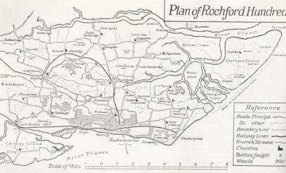
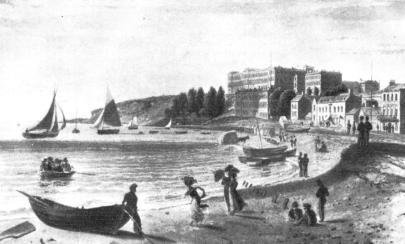
Southend-on-Sea
1822 Southend
Dating
from
Saxon
times
the
“Hundred”
was
a
system
of
land
measurement.
This
was
a
subdivision
of
a
county
or
shire
and
had
its
own
court.
It
consisted
of
100
parcels
of
land
(hides)
of
land,
each
capable
of
supporting
a
family,
which
could
be
an
extended family up to fifty people


Website Info:

Southend-on-Sea’s No 1 History Website! Documenting The Town & The Townspeople
Now Incorporating The Sea Of Change Website


SOUTHEND CITY
Chalkwell ▪ Eastwood ▪ Leigh-on-Sea ▪ Prittlewell ▪ Shoeburyness ▪ Southchurch ▪ Thorpe Bay ▪ Westcliff-on-Sea


